Dependency on US based Global positioning system (GPS) for navigation and other surveying and mapping work will see its limitation in our country as India has developed its own regional Navigational Satellite System which will cover Indian territory as well as extends its regions nearby to 1500 Kms further.
Till Date our dependency was on GPS for location-based services. The GPS service is provided by the United States government, and at times they decide the access of their system. During Kargil war Indian Government had asked for location of infiltrators on high hill area however they denied doing so. This triggers the necessity of setting up other global or regional satellite navigation systems.
Approach towards Navigation Satellite by other countries:
The Russian Global Navigation Satellite System (GLONASS) was developed contemporaneously with GPS but suffered from incomplete coverage of the globe until the mid-2000s.GLONASS can be added to GPS devices, making more satellites available and enabling positions to be fixed more quickly and accurately, to within two meters. China’s BeiDou Navigation Satellite System began global services in 2018, with full deployment scheduled for 2020. There is also the European Union Galileo positioning system. Japan’s Quasi-Zenith Satellite System (QZSS) is a GNSS satellite-based augmentation system to enhance GNSS’s accuracy in Asia-Oceania, with satellite navigation independent of GPS scheduled for 2023.
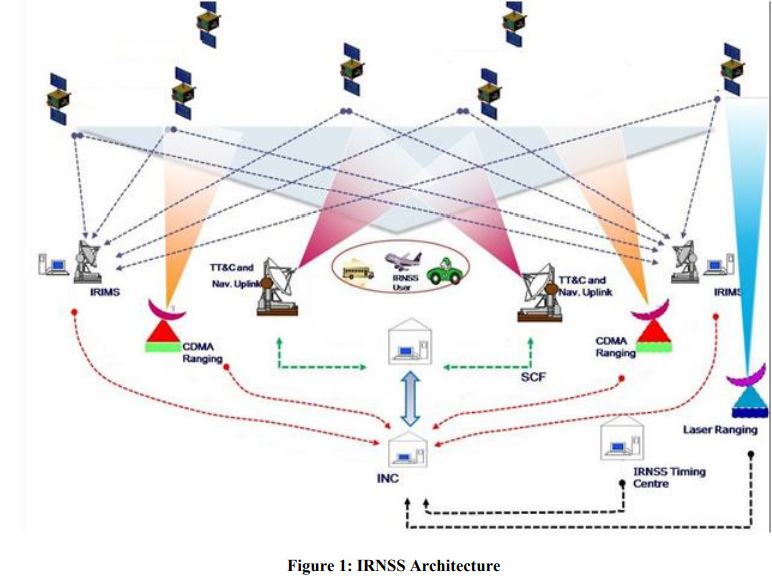
About IRNSS
IRNSS is an independent regional navigation satellite system being developed by India. It is designed to provide accurate position information service to users in India as well as the region extending up to 1500 km from its boundary, which is its primary service area. An Extended Service Area lies between primary service area and area enclosed by the rectangle from Latitude 30 deg South to 50 deg North, Longitude 30 deg East to 130 deg East.
IRNSS will provide two types of services, namely, Standard Positioning Service (SPS) which is provided to all the users and Restricted Service (RS), which is an encrypted service provided only to the authorised users. The IRNSS System is expected to provide a position accuracy of better than 20 m in the primary service area.
Some applications of IRNSS are:
- Terrestrial, Aerial and Marine Navigation
- Disaster Management
- Vehicle tracking and fleet management
- Integration with mobile phones
- Precise Timing
- Mapping and Geodetic data capture
- Terrestrial navigation aid for hikers and travellers
- Visual and voice navigation for drivers
Availability of IRNSS in Mobile chipset for use in India:
The Indian Space Research Organisation (ISRO) has announced that it has provided consultation for Qualcomm towards enabling NavIC capability in their Snapdragon mobile chipset platforms. Qualcomm Technologies, a wholly-owned subsidiary of Qualcomm Incorporated, had announced support for Navigation with Indian Constellation (NavIC), in select chipset platforms of the company last year.
ISRO has now officially announced that these chipsets are being released by Qualcomm Technologies. “The release of chipsets will help accelerate the adoption of NavIC by smartphone OEMs. The OEMs can now release any new models for Indian market which are NavIC enabled, thus eventually making NavIC as a standard feature in the upcoming handsets, applications, processors, etc. It will also enhance the geolocation capabilities of smartphones within the coverage region of NavIC,
What is ISRO Navic? What Are its Benefits?
NavIC is India’s autonomous regional satellite navigation system that provides accurate real-time positioning and timing services. NAVIC will provide standard positioning service to all users with a position accuracy of up to 5m, which is even better than the Global Positioning System (GPS) position accuracy of 20 to 30m. Some of the applications of NaVIC are listed as follows:
- Integration with mobile phones.
- Vehicle tracking and fleet management.
- Visual and voice navigation for drivers.
- Terrestrial navigation aid for hikers and travellers.
- Disaster Management.
- Precise Timing.
- Terrestrial, Aerial and Marine Navigation.
Reference:
The details mentioned in this article has been compiled using information from below mentioned source.
https://www.isro.gov.in/update/21-jan-2020/launch-of-mobile-chipset-compatible-to-navic
https://www.isro.gov.in/sites/default/files/irnss_sps_icd_version1.1-2017.pdf
https://www.isro.gov.in/irnss-programme